Spatial Data Management & Analysis

The rapid development of, and ease of access to, high quality satellite imagery and inexpensive and accurate Global Positioning System (GPS) navigation devices can allow policy makers to monitor forest cover and to make informed spatial plans that facilitate sustainable development.

Training and Internships

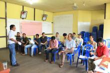
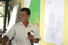
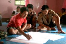
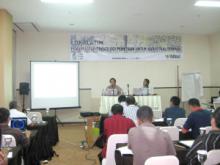
SEKALA provides training and internships on Geographic Information Systems (GIS), satellite image processing, remote sensing, spatial planning, REDD+ and community mapping to various stakeholders, including government officials, Non Government Organisations (NGOs), private enterprise and local communities.

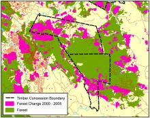
Some of these training workshops aim to initiate discussion among civil society and local forestry offices about data availability, data inconsistencies, information sharing mechanisms, standards, metadata and analysis.

Program Management

SEKALA aims to provide quality program management support for Indonesian organizations working on environmental and natural resource management issues. It primarily assists organizations to:

  • Develop proposals
  • Conduct baseline appraisals
  • Develop participatory Monitoring and Evaluation schemes
  • Map out influential and important stakeholders.
  • Write project reports

Community Mapping Support

Community mapping is a tool that allows customary people to map their land and forest resources in a participatory way. It can also be used to mediate land use conflicts and to provide an avenue for stakeholders to negotiate and agree upon spatial plans and customary boundaries.

SEKALA has provided community mapping support in Kalimantan, Sulawesi, Sumatra and Papua. It has also helped to improve community mapping methodologies and to support community mapping networks throughout the archipelago.

Satellite Image Provider

SEKALA acts as a satellite image provider and is able to assist organizations to enhance, rectify, mosaic and interpret satellite images.

As part of this service, SEKALA is able to:

Fire Detection and Management

Fire is commonly used in Indonesia to clear land for swidden agriculture and large-scale oil palm developments. While fires can be contained they have often become widespread and damaging. SEKALA collects satellite and spatial data on forest and land fires and is able to provide ground-truthed data on fire hotspots. SEKALA also analyses this data to develop realistic strategies that can be used to reduce forest fires in Indonesia.

REDD+ Support

Deforestation and land-use change are a leading cause of global warming. They account for 20-25% of global carbon emissions, and over a third of emissions from developing countries. In Indonesia, deforestation and land-use change are estimated to account for 80% of Indonesia’s carbon emissions and 6% of global greenhouse gas emissions. Carbon emissions released from the logging, burning and conversion of Indonesia’s forests and peatlands have helped make Indonesia the world’s fourth largest greenhouse gas polluter after the USA, European Union and China.

Conflict Mediation

Conflicts over natural resource use and management are common in Indonesia as large-scale concession boundaries often overlap with customary lands. SEKALA uses conflict mediation, community mapping, and other services to help to resolve these conflicts.

For instance, SEKALA has worked together with the International Finance Corporation (IFC) and an industrial timber plantation company (PT MHP) in South Sumatra to analyse and to help to resolve land conflict arising with local communities living in the PT MHP concession area.

Provision of Baseline Data and Cadastral maps

SEKALA has developed a systematic methodology to compile, collect, analyse and improve statistical and spatial data relevant for REDD+, natural forest management and spatial planning. SEKALA has developed proficiency in identifying data inconsistencies, harmonising spatial data and facilitating consensus about data discrepancies through multi-stakeholder dialogue. SEKALA has been engaged by the United Nations Development Program (UNDP) and Indonesia’s REDD+ Agency to undertake this work in the provinces of East Kalimantan, Central Kalimantan, Papua and West Papua.

Strategic Environmental Assessment

Strategic Environmental Assessment is a systematic decision support process, aiming to ensure that environmental and other sustainability aspects are considered in policy planning and programme making.

SEKALA has developed experience and received training in carrying out Strategic Environmental Assessments (SEA) in Indonesia.

Pages